While the Middle Fork of the Salmon River is extremely well-known for its world-class whitewater and fly fishing expeditions, there is yet another draw to this wilderness area for outdoor-enthusiasts — hiking the Middle Fork Trail.

Day One
Boundary Creek to Sheepeater Hot Springs
13 miles
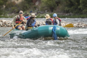
Hiking the Middle Fork trail starts where most everything Middle Fork related begins — at Boundary Creek. This is where the road ends and the Frank Church River of No Return Wilderness unfolds. Backpackers will load their gear on their backs and take off on foot not far from where boaters are sliding their rafts down the ramp and into the clear waters of the river.
Starting at Boundary Creek means you are taking off into an alpine environment — at almost 6800 feet in elevation, hikers might feel the altitude slightly, and will definitely note the cool nighttime temperatures. For the most part, hiking the Middle Fork trail takes you downstream, but not necessarily downhill.
For the first few miles, the trail takes you through sub-alpine forests that are beautiful but not wholly intact — forest fires over the years have thinned the trees, and while new saplings are springing up quickly, hikers will travel though open swaths of post-burn meadows as well as thick stands of forest. In the spring and throughout summer, these meadows will be resplendent with differing types of wildflowers.
The Middle Fork trail never strays far from the river in it’s beginning section, but even walking just a couple hundred feet away from the rushing of the water can transport you to another realm in the wilderness. Glimpses of the river from above are transfixing, and offer a new perspective of the Salmon River.

About eight miles into the hike there lies your first publicly accessible hot springs at Trail Camp, so depending on how many miles you are trying to make on day one, this might be a nice stop for a late lunch or even for camp! Take off your boots and soak your feet in this riverside hot springs. Its a popular spot, so expect to share it with boaters.
Continuing on another couple of miles will take you past the Joe Bump historical cabin as well as the grave of Elmer Purcell right alongside the trail. Just around the river bend from there will take you to your second hot springs of the trip, Sheepeater Hot Springs at around mile 13. This is a fantastic end to a first day hiking the Middle Fork trail.

Day Two
Sheepeater Hot Springs to Indian Creek
13.3 miles
After the well-wooded and intact forests of the Sheepeater area, the next section of the trail will feel starkly different and much more exposed. The area first burned in the Mortar Creek fire of 1979 and had shown promising regrowth before another fire torched the young trees anew. The entirely of the trail through the Artilleries section is a burn scar.
This means that while hikers will be significantly more exposed to sun, they will also have incredible 360-degree views of the wilderness area surrounding and river below. You will pass fields of shrubs and flowers as well as rippling creeks and newly sprouting pines.

At around mile 19, the forest returns, hopefully in time for an afternoon lunch in the shade. The Dolly Lake area of the river is a stunning spot to be viewed from above. The river takes a bend and a large cliff wall forms a deep, dark pool, one of the first such spots on the Middle Fork. This is an excellent area to head into the river and take a swim in a lake-like setting.
Continuing downstream, the trail continues through a forest that is gradually changing in character. You are leaving the sub-alpine and transitioning into a montane forest environment populated predominantly by Douglas Fir and Ponderosa Pine trees, as well as Lodgepole Pine.
The large canopies of the Ponderosa and Douglas Firs will be a welcome relief from the sun after an exposed morning on the trail. Soon after Dolly Lake, you will hike past Pistol Creek Rapid and over Pistol Creek itself. This might be a good spot to stand above the river and watch as rafts run through the class IV rapid below.
A mile or so after the rapid, your route will take you to a surprising place — a ranch in the wilderness, with around 20 homes nestled along and airstrip and the river banks. This is private property, and while hiking the Middle Fork Trail through here is permitted, do so respectfully.


Just a few more miles downstream, and you will come across the Indian Creek Guard Station at mile 25 of the Middle Fork Salmon river and trail. This serves as a starting point for some river trips as well as an informational hub in the wilderness area. Hiking the Middle Fork Trail past this hub, you can refill your water, talk to rangers, volunteers or boaters, and use the Phoenix 5000 pit toilet.
The trail continues past an active airstrip and along the river. The Indian Creek Bridge crosses the river not far downstream from the station and is the first bridge on your trek. However you must remember not to actually cross the bridge, only admire it. This bridge serves as access to the Rapid River trail system upstream.
Soon after, you will cross a small scenic bridge over Indian Creek itself and find a nice little campsite at the confluence of the creek and river. Head a little ways up Indian Creek if you are curious, or just relax riverside for the evening.
Day Three
Indian Creek to Little Creek Guard Station
9.5 miles
First thing in the morning, the trail will take you past another historical site at Pungo Creek. Here there are remnants of the foundation of an old cabin, as well as a mine tunnel you can enter. Hiking the Middle Fork Trail past this site, you enter Pungo Canyon, and hike through steep walls and tall trees, with many wildlife sitings and beautiful views of the rapids in the river.
After exiting the canyon, you will come around a bend and pass through the very large Marble Creek camp at mile 32, just above Marble Creek itself and its rapid. Crossing Marble Creek is a lovely footbridge. If you continue a short ways up the Marble Creek trail, you will come across several pictographs.

The trail is smooth and steady after Marble Creek for several miles, passing Ski Jump rapid below, as well as Sunflower Hot Springs across the river. If your timing is right and there is group camped at Lost Oak camp site, maybe a raft can ferry you across the river to the hot springs (and hot shower!).
Continue hiking the Middle Fork trail along a rolling stretch that will take you to the second bridge across the river, and much like the first, this is not a bridge you are supposed to use on your journey. It gives access to the exclusive and privately-owned Middle Fork Lodge. The land you are now traversing is actually owned by the state of Idaho.

You will past several large camps as well as another airstrip called Thomas Creek, where another bridge crosses the river. Third time is a charm, this is the bridge that you should cross. There is a trail that continues on the left side of the river to the White Creek Bridge, but most hikers choose to cross to the trail on the right side of the river. The trail is more used and tends to stay closer to the river, which will bring crucial in the next stage of your trek.
The Little Creek Guard Station at mile 35 across the bridge is a great place to call it a day. There is ample shade, flat ground to camp, and sometimes Forest Service trail crew members to befriend. This site is also home to one of the largest Ponderosa pine trees in the river corridor, so take off your pack and stretch out in it’s shade.
Day Four
Little Creek Guard Station to Loon Creek
12 miles
Heading out from the Little Creek Guard Station will take you up above the river through a long straightaway ending at Jackass Rapids and camp. Just past the camp is a side trail on the right that will lead you up a short but very steep scramble to Jackass Point. I suggest leaving the backpacks trailside and bringing your cameras up to this stunning overlook.
After that side quest, the trail continues through Lower Jackass camp along a mellow and shaded section before crossing Little Loon Creek. From here, you are transitioning once again into a high desert environment characterized by abundant sagebrush and sparse trees. It is wise to get an early start heading into this terrain while hiking the Middle Fork Trail, as afternoons can get to be quite hot and exposed.

A place of interest you will pass is the Cougar Creek Ranch, settled in 1908. The land and property is now owned by Idaho Fish and Game. There is still a cabin standing here, as well as an airstrip.
Once past the remnants of the Mahoney Creek Ranch, the trail takes you up and away from the river for a ways, and it is a change of pace and scenery that might be welcome or not depending on the weather. You come back to the river near Pine Flat rapids, where red-orange bedrock protrudes from the banks and from under the water. This is an amazing sight to be seen from above on the trial.
Just after Pine Flat is the remains of yet another historical cabin, once owned by Fred Paulson. Shortly after this you will hit Red Bluff creek, an oasis of shade and a beautiful creek where you can rest and refill your water. The trail leads you up and over the unusual and striking red bluff cliff, and the views of the river below and land beyond are incredible. Looking downstream from this vantage point you can see the jagged ridges and pink-orange cliffs above the Whitie Cox area.

You will continue along straight downstream after this, crossing Culver Creek before turning sharply right and heading into Whitie Cox camp on a high bench above the river. This area is named after the man who first settled here and is also home to his grave, a large white military headstone that river users have covered with old antlers and bones. There is also a shallow and strange hot spring here that is said to be infested with strawberry mites.
The trail bends again and heads into a deeper section of the canyon, with those same towering pink granite cliffs exposed by the dead snags of a fire in the early 2000s. Along the river and the trail, however, remains a healthy forest for the most part, and the shade here is most appreciated.

Soon you will pass White Creek Bridge which offers a beautiful vantage point over the river and a long deep pool. Keep going, because just around a couple of river bends is Loon Creek camp and hot springs! The trail is mild and shaded as you end your day on foot, stopping somewhere in the vicinity of Loon Creek. There is a popular boater’s camp by the river, but I suggest staying upstream of Look Creek on a large flat bench inaccessible to the river folk. There is ample access to the creek as well as a trail to the hot spring.

Day Five
Loon Creek to Aparejo Creek
14 miles
Starting off on day five, you should feel refreshed and ready to hike some miles after a relaxing evening spent at the Loon Creek hot springs. You will set off hiking the Middle Fork Trail downstream and around a bend before reaching a spectacular view of Underwater Canyon, which look exactly how it sounds, but is even more remarkable in reality.
Next you will enter the Grouse Necks, a section that is known for its many bends and relatively little action. The trail goes the same as the river and it is very easy to make some good miles here in the morning before the sun gets too hot. You will be mostly exposed along this section, with some areas of tree coverage along creeks or down by the river.


At around mile 54 you will cross Little Aparejo Creek, which is a nice place to fill water. After that, it is several more turns in the river until you reach the Grouse Creek area. The trail will cross a long and very flat bench before passing a sandy beach and shaded camp, Lower Grouse. You will then come to Daisy Tappan’s cabin and the start of Tappan Canyon.
This is an excellent spot to enjoy lunch and cool off in the shade of Grouse Creek behind the cabin. Spending time here where Daisy and her two sons once lived a rough but remarkable life is a humbling thing.
The trail enters the canyon, and you will soon be surrounded by towering granite cliffs and mighty ponderosas. The rapids below are challenging and a wonder to admire from above. Take your time and plenty of photos through this section of the canyon, as it ends as abruptly as it begins.

Exiting the canyon, the trail turns right with the river and you are soon at Camas Creek at mile 60. The trail makes it way up the creek, one of the largest tributaries of the Middle Fork, before crossing and continuing downstream. This is a beautiful section of the trail, winding through sagebrush as well and huge ponderosas, with sweeping vistas and high peaks in the distance, characterized by the unique pink granite that has been a companion for the last two days on trail.
The next canyon, Aparejo Canyon, is also short and sweet and sculpted of pink granite. These are some of the most beautiful turns you will make on your hike, as bends in the river reveal ever steeper walls and deeper pools. There is a lovely and quiet spot to camp on Aparejo Creek, as well as around the bend at Trail Camp, a popular boating camp. You can spend your evening bathed in the rose-colored light reflecting from the canyon walls.

Day Six
Aparejo Creek to Big Creek
14.3 miles
This is the last day of your hike along the Middle Fork Salmon River, but not the last day of your trek overall! You will still be deep in the Frank Church River of No Return Wilderness and will have to choose a route out. But for the time being, you can enjoy a final dynamic stretch on the Middle Fork Trail.
Leaving camp in the morning will take you around one last bend in Aparejo Canyon, and the same walls that were alit with alpenglow in the evening will be flushed with the light of dawn. The walls will open up around you and take you into a large valley, the last of its kind on the Middle Fork. You will pass the Mormon Ranch, settled in 1902 by a pair of brothers. It is now owned by Idaho Fish and Game.
The rolling hills in this area are mostly populated by sagebrush, and higher up the slopes are skeletons of trees burned in the 2000 fire that almost completely razed the historic Flying B Ranch just around the corner. There is a bridge across the Middle Fork lending access to the ranch, which has a shaded sitting area, filtered water, and a small store for any must-have needs or souvenir trinkets for those hiking the Middle Fork Trail.


After the Ranch, the trail works its way through the scrub towards the imposing entrance to Jack Creek Canyon. Make sure to glance back at the wide open skies behind, because the rest of the Middle Fork Trail will take you into deep canyons. There is a series of rapids at the start of the canyon called Haystack and Bernard rapids, formed by smooth and monolithic chunks of polished pale granite.
In this area, it is very common to see big horn sheep, so keep your eyes peeled on the tall cliff walls and the places you’d least except, as these creatures seems to defy gravity. Heading into the canyon, you will be surrounded by steely gray granite cliffs highlighted by bright green lichen and rust orange iron deposits, a completely different feel from previous canyons.

After a long straightaway, the trail will start to bend left and you will cross Cold Springs Creek, an excellent spot to fill up on water. From there, the trail heads uphill and you come around the next bend hundreds of feet above the river on a sheer cliff face.
Coming down, you will pass Earthquake Rock rapid, formed by the 1983 earthquake on Mt Borah. The trail will take you through several scree fields below massive walls before crossing Jack Creek. On either side of the river, the riverside cliffs near the water have been worn smooth by years of raging flows through this steep section of canyon, and the trail runs directly below the sculpted face.
Continuing through Jack Creek canyon will take you up and over another rise to even more dramatic views before winding down though Driftwood camp, along another straightway surrounded by very jagged outcroppings, before passing through Wilson camp and over Wilson creek. This creek crossings is one of my favorites, as you can hardly imagine a more idyllic scene. This might be the perfect place to stop for lunch and enjoy the serenity of running water.

The trail and the scenery along the way both become steadily more striking while hiking the Middle Fork Trail, as the hills and cliffs along the river give way to peaks and ridges above and beyond, and the scale of perception begins to shift and expand.
Soon you will come to one of the more challenging routes on the Middle Fork Trail that is also one of the most rewarding. The trail runs up Woolard Creek to navigate around a massive outcropping over the river that forms Rattlesnake Cave. Before heading up the creek, make sure to take a detour down to check out the cave and its spectacular panel of pictographs.
It gets steep here, and you will trudge 500 feet up the creek through a series of impressive switchbacks. Take plenty of breaks along the way and admire the different views as you ascend. Reaching the top, there is a side trail to an overlook that will give you panoramic views of the river both directions, the small valley above Woolard camp, Survey camp, and beyond.

Coming down the ridge will take you across a grassy field before the trail cuts into the cliff face again. Make sure to check out the walls along the trail here as there is a singular pictograph panel along the route. From here the trail will take you deeper into the gorge and past more impressive formations high above along the cliffs and down below in the river.
Eventually you will round a final corner and find yourself above Waterfall Creek rapids, thankful you don’t have to navigate a raft through the boulder garden, and facing one of the best views of the entire trek: the confluence with Big Creek and the start of Impassable Canyon.
There is a final bridge here that crosses the Middle Fork to lend access to the Big Creek trail. A small and rocky camp exists at the mouth of Big Creek. There is also sometimes a nice beach just beyond the bridge on river right that you can pick your way down to, or Last Chance camp also on river right that gives you an exceptional view into the final canyon of the Middle Fork on your final night on the Middle Fork Trail.

Getting Out
Before the trek even begins, it is important to choose an egress route, as the Middle Fork Trail officially ends at Big Creek. You can choose to hike up Big Creek to Taylor Ranch, around 7 miles upstream, and arrange a backcountry flight ahead of time to pick you up and fly you out of the wilderness. You may also choose to hike the entirety of Big Creek to the Big Creek/ Smith Creek Trailhead, but this will add significant time to any trip.
The third choice is to head up and out through the Big Horn Crags mountain range on river right, approximately 22 miles to the Crags Campground. This is an extremely challenging route, mostly due to the steep terrain, but also amazingly impressive, taking you through towering granite spires and past cerulean alpine lakes.

It is possible to make it up to Terrace Lakes in one day thanks to the efforts of a trail crew with the Selway-Bitteroot foundation, but the trail climbs 11 miles and 5,600 feet — the ranges here are not for the faint of heart. From there it is a slightly easier cruise another 11 miles to the trailhead and campground.
No matter what option you choose, your journey is not over once the Middle Fork Trail ends! The Frank Church River of No Return Wilderness area is as rugged as it is huge, and the Impassable Canyon is so named because it was nigh impossible to build a trail through. Days 7 and 8 and even 9 will be more challenging than your rolling days along the river, but arguably even more extraordinary.